Perry-Castañeda Library
Map Collection
Afghanistan - Tactical Pilotage Charts (Not for Navigational Use) 1:500,000

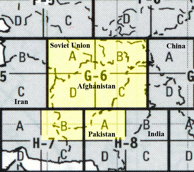
Click on the highlighted section you wish to view.
- TPC G-6A Published by the Defense Mapping Agency Aerospace Center, 1989. Includes parts of Afghanistan, Iran, and the USSR. Scale of 1:500,000 (14.9MB) Not for navigational use
- TPC G-6B Published by the Defense Mapping Agency Aerospace Center, 1981. Includes parts of Afghanistan, the USSR, Pakistan, and China. Scale of 1:500,000 (12.8MB) Not for navigational use
- TPC G-6C Published by the Defense Mapping Agency Aerospace Center, 1992. Includes parts of Afghanistan, Pakistan, and India. Scale of 1:500,000 (13.5MB) Not for navigational use
- TPC G-6D Published by the Defense Mapping Agency Aerospace Center, 1991. Includes parts of Afghanistan, Turkmenistan, and Iran. Scale of 1:500,000 (13.7MB) Not for navigational use
- TPC H-7B Published by the Defense Mapping Agency, 1995. Includes parts of Afghanistan, Iran, and Pakistan. Scale of 1:500,000 (11.5MB) Not for navigational use
- TPC H-8A Published by the Defense Mapping Agency Aerospace Center, 1991. Includes parts of Afghanistan, Pakistan, and India. Scale of 1:500,000 (12.2MB) Not for navigational use
Details of TPC G-6C:
- Jalalabad, Afghanistan - Peshawar, Pakistan Region (tactical pilotage chart) original scale 1:500,000 Portion of Defense Mapping Agency TPC G-6C 1992 (774K) Not for navigational use
- Kabul - Khowst (Khost) Region (tactical pilotage chart) original scale 1:500,000 Portion of Defense Mapping Agency TPC G-6C 1992 (903K) Not for navigational use
- TPC G-6B Published by the Defense Mapping Agency Aerospace Center, 1981. Includes parts of Afghanistan, the USSR, Pakistan, and China. Scale of 1:500,000 (12.8MB) Not for navigational use
Complete list of map images in this collection: